Introduction
As geospatial data generation accelerates due to the proliferation of IoT devices, satellites, and sensors, the demand for real-time analytics has surged. Traditional centralized computing struggles to keep up with the velocity and volume of data. Enter edge computing, a distributed paradigm that processes data closer to its source. By enabling real-time geospatial analytics, edge computing is revolutionizing fields like disaster management, autonomous vehicles, and precision agriculture.
What is Edge Computing?
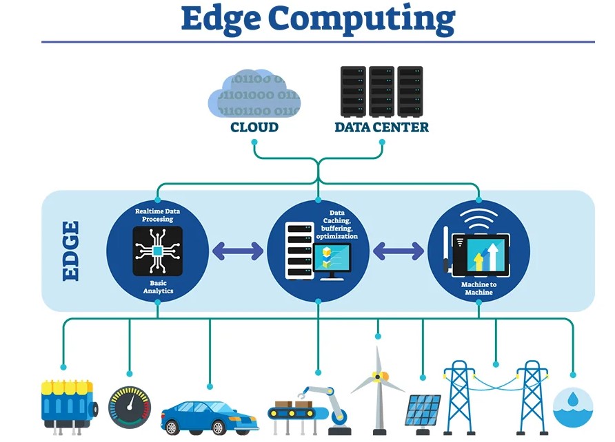
Edge computing involves processing data at or near the source of generation rather than relying on centralized cloud servers. This approach minimizes latency, reduces bandwidth costs, and enhances data security.
Why Geospatial Analytics Needs Edge Computing
- Massive Data Volumes: Satellites and IoT sensors generate terabytes of geospatial data daily.
- Real-Time Decision Making: Applications like disaster response and autonomous vehicles require near-instantaneous insights.
- Bandwidth Limitations: Transmitting raw data to cloud servers for analysis can overwhelm networks.
- Intermittent Connectivity: Edge computing ensures functionality in remote areas with limited connectivity.
Applications of Edge Computing in Geospatial Analytics
- Disaster Management:
- Edge-enabled drones and sensors analyze flood extents, wildfire progression, or earthquake damage in real time.
- Immediate data processing supports timely rescue and recovery operations.
- Autonomous Systems:
- Self-driving cars rely on edge computing to process LiDAR and GPS data for real-time navigation.
- Drones use edge analytics for obstacle detection and mapping in dynamic environments.
- Precision Agriculture:
- Edge computing devices analyze soil moisture, temperature, and crop health directly on the farm.
- Farmers receive actionable insights without needing high-bandwidth internet.
- Smart Cities:
- Real-time traffic monitoring and route optimization.
- Edge-based sensors monitor air quality, noise levels, and urban heat islands.
- Defense and Security:
- Edge systems process geospatial data from surveillance drones and satellites, enabling rapid threat detection.
Technologies Powering Edge Computing in Geospatial Analytics
- Edge AI Chips: Specialized hardware like NVIDIA Jetson and Google Edge TPU accelerates geospatial AI at the edge.
- 5G Networks: Ultra-low latency and high bandwidth support seamless edge computing for geospatial applications.
- Micro Data Centers: Portable data centers provide computational power in remote or challenging environments.
- Distributed Storage: Systems like Apache Kafka and edge-based Hadoop enable scalable data management.
Challenges and Limitations
- Scalability: Deploying and maintaining edge devices across vast areas is challenging.
- Interoperability: Ensuring seamless integration between edge devices and cloud systems requires standardization.
- Energy Efficiency: Edge devices in remote locations must balance computational power with limited energy resources.
- Security Risks: Distributed systems are vulnerable to localized attacks and data breaches.
Future of Edge Computing in Geospatial Analytics
- AI at the Edge: Advanced AI algorithms will be deployed on edge devices for real-time geospatial data analysis.
- Hybrid Architectures: Combining edge computing with cloud-based systems for enhanced scalability and flexibility.
- Decentralized Geospatial Systems: Edge computing will support decentralized frameworks, democratizing access to geospatial analytics.
- Emerging Use Cases: Applications like geospatial augmented reality and real-time climate monitoring will benefit from edge computing advancements.
Conclusion
Edge computing is reshaping the geospatial analytics landscape by enabling real-time, localized data processing. As the technology matures, it will unlock new possibilities, from smarter cities to more resilient disaster management systems. Geospatial professionals must embrace this transformative paradigm to stay ahead in a rapidly evolving digital ecosystem.