Introduction
Artificial Intelligence (AI) is revolutionizing the geospatial industry, transforming how Earth observation data is collected, analyzed, and applied. Geospatial AI, or GeoAI, combines advanced AI techniques with geospatial data, enabling unprecedented insights and solutions for global challenges. This article explores how GeoAI is reshaping the landscape of Earth observation and what the future holds for this transformative technology.
What is Geospatial AI?
Geospatial AI refers to the integration of machine learning (ML) and deep learning techniques with geospatial data to automate analysis, detect patterns, and generate actionable insights. This fusion enables rapid, scalable solutions across diverse fields.
Key Applications of GeoAI
- Environmental Monitoring
- Monitoring deforestation and land-use changes using satellite imagery and AI models.
- Predicting climate patterns and assessing the impact of human activities on ecosystems.
- Disaster Management
- AI-driven real-time analysis of satellite data for flood mapping, wildfire tracking, and earthquake damage assessment.
- Automated alert systems for early warning and emergency response coordination.
- Urban Planning
- Analyzing population density, transportation networks, and resource distribution for smarter urban design.
- GeoAI models optimize infrastructure planning, reducing costs and environmental impacts.
- Precision Agriculture
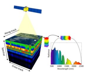
- Classifying crop types, monitoring health, and predicting yields using multispectral and hyperspectral imagery.
- AI-powered models detect pest infestations and irrigation inefficiencies.
- Defense and Security
- Surveillance and threat detection through automated analysis of high-resolution imagery.
- Border monitoring using geospatial AI for enhanced national security.
Technologies Driving GeoAI
- Deep Learning
- Convolutional Neural Networks (CNNs) for image classification and object detection in satellite imagery.
- Recurrent Neural Networks (RNNs) for analyzing temporal geospatial data trends.
- Natural Language Processing (NLP)
- Geotagging textual data from social media, news reports, and other sources for situational awareness.
- Automated interpretation of geospatial metadata.
- Generative AI
- Simulating scenarios such as urban growth patterns or disaster impacts using generative adversarial networks (GANs).
- Filling gaps in incomplete geospatial datasets with realistic reconstructions.
- Big Data Analytics
- Processing and analyzing petabytes of geospatial data from satellites, drones, and IoT sensors.
- Cloud-based platforms like Google Earth Engine and Amazon SageMaker enable scalable GeoAI solutions.
Challenges in GeoAI Implementation
- Data Quality and Availability: Limited access to high-quality, labeled geospatial data for AI model training.
- Computational Resources: High computational costs associated with training and deploying large AI models.
- Ethical Concerns: Balancing innovation with privacy, security, and bias issues in geospatial applications.
- Interoperability: Ensuring seamless integration of AI with diverse geospatial tools and platforms.
Future Trends in GeoAI
- AI-Powered Satellites: Satellites with onboard AI for real-time image analysis and autonomous decision-making.
- Explainable GeoAI: Development of transparent AI models to improve trust and adoption in critical applications.
- Hybrid GeoAI Models: Combining multiple AI techniques (e.g., deep learning, reinforcement learning) for comprehensive solutions.
- Edge AI in Geospatial Analytics: Deploying AI algorithms directly on edge devices for faster processing and reduced latency.
Conclusion
Geospatial AI is unlocking new possibilities for addressing global challenges, from climate change to urbanization. By combining AI with Earth observation data, professionals can derive actionable insights, enhance decision-making, and create innovative solutions. As GeoAI continues to evolve, its transformative potential will reshape industries, making the future of geospatial intelligence both exciting and impactful.