Introduction
In the era of big data, managing and analyzing vast amounts of remote sensing data can be overwhelming. Enter data cubes—a revolutionary approach to organizing, processing, and analyzing geospatial data. By providing a multidimensional structure, data cubes are transforming how remote sensing data is handled, from basic storage to advanced analytics.
This article explores the fundamentals of data cubes and their advanced applications in remote sensing, positioning them as indispensable tools for researchers, analysts, and policymakers.
What Are Data Cubes?
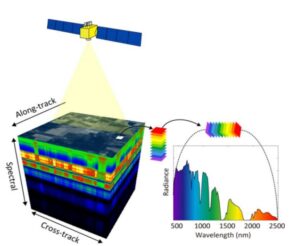
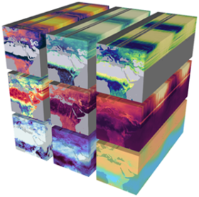
At their core, data cubes are a type of multidimensional array that organize data across spatial, temporal, and spectral dimensions. Unlike traditional flat-file storage systems, data cubes enable structured access to datasets, simplifying complex analyses.
Key Features:
- Multidimensional Representation: Data is stored in dimensions such as latitude, longitude, time, and spectral bands.
- Efficient Querying: Optimized for rapid retrieval of specific subsets of data.
- Scalability: Capable of handling terabytes of remote sensing data seamlessly.
Evolution of Data Cubes in Remote Sensing
Initially developed for business intelligence applications, data cubes have found significant utility in geospatial and remote sensing domains. Modern geospatial data cube platforms integrate with cloud computing, artificial intelligence, and machine learning to enhance their capabilities.
Advantages of Data Cubes
- Enhanced Data Management:
- Centralized storage eliminates redundancy.
- Uniform data formatting streamlines workflows.
- Temporal Analysis:
- Enables time-series analysis for monitoring changes in land use, vegetation, and urbanization.
- Interoperability:
- Compatible with diverse data sources, including satellite imagery, aerial photographs, and in-situ observations.
- Accessibility:
- Open platforms like Open Data Cube make geospatial data cubes accessible to a broader audience.
Applications of Data Cubes in Remote Sensing
- Land Use and Land Cover Change (LULC):
Data cubes allow for detailed analysis of changes in land cover over time, aiding urban planning and conservation efforts. - Climate Change Monitoring:
- Analysis of temperature anomalies, glacial retreat, and deforestation trends.
- Long-term data availability supports predictive modeling.
- Agriculture:
- Monitoring crop health, soil moisture, and yield predictions.
- Combining spectral and temporal data improves precision farming.
- Disaster Response:
- Rapid analysis of satellite data to assess flood extents, wildfire damage, and earthquake impacts.
- Supports early warning systems and post-disaster recovery planning.
From Basics to Advanced Analytics
Basics:
- Data Cleaning and Preprocessing: Ensure uniformity in spatial resolution, temporal alignment, and spectral calibration.
- Visualization: Simple 2D and 3D visualizations for exploratory analysis.
Advanced Analytics:
- Machine Learning and AI:
- Automating land cover classification.
- Predicting crop yields using historical and real-time data.
- Integration with Big Data Platforms:
- Cloud-native implementations for massive datasets, e.g., Google Earth Engine, AWS.
- Parallel processing for high-performance computing.
- Modeling and Simulation:
- Hydrological and climate models integrated with data cubes.
Challenges and Opportunities
Challenges:
- Data Standardization: Harmonizing diverse datasets across platforms.
- Computational Costs: High-performance infrastructure is essential for large-scale analysis.
- Skill Gaps: Analysts require expertise in programming and geospatial analytics.
Opportunities:
- Global Initiatives: Platforms like Open Data Cube and Digital Earth Africa promote collaboration and knowledge-sharing.
- Emerging Technologies: AI-driven automation, blockchain for secure data transactions, and quantum computing hold transformative potential.
Conclusion
Data cubes represent a paradigm shift in the way remote sensing data is managed and utilized. By offering a structured and scalable approach, they bridge the gap between data availability and actionable insights. From basic data storage to advanced analytics, data cubes are empowering decision-makers to address critical challenges like climate change, food security, and urban growth effectively.
As we continue to embrace new technologies, the potential of data cubes to revolutionize remote sensing is only just beginning.